I’m still following my recent interest in wireless networks and devices. In the past month I gained a USB gps reciever (which I forgot to write about, may have a short review shortly). After adding gps capability to my wardrive setup I proceed to scan the local area, then hit a brick wall. There appears (could be my google-fu is failing me) a lack of available tools to meaningfully use the captured data.
After a lot of digging a stumbled upon this script, designed to parse the output from Kismet and generate a .kml file to import into Google Earth. Unfortunately, I’ve been unable to get this to work as Google Earth complains when opening the file. Could be a version issue so your mileage may vary, if anyone does get it working please let me know.
The PerryGeo code did however provide an excellent foundation to utilise the Kismet log file and generate different output. To this end I have released a basic proof of concept script that generates a static map via the Google Maps API. If you want to do anything similar, or want to extend or modify my image code I found the Google documentation to be invaluable.
To the tool itself, starting a disclaimer:
This tool should not be used for illegal or malicious purposes. It was created to visualise network locations and implemented encryption technologies, in an effort to enhance previous analysis of wireless network statistics.
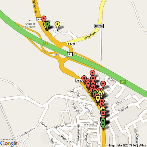
For each discovered access point, the script places a marker on the map, colour coded to level of encryption: Open access points are green, WEP encrypted access points are yellow, whilst WPA encrypted APs are red.
The Google maps API appears to have a limit to the length of URL that it is able to support, as a result the script limits the plotted APs to the first 50 in a given Kismet xml log file. This should be sufficient for site surveys, but is less useful for mapping the results from a wardrive trip. I haven’t manage to locate any firm documentation on this limit, if anyone is able to shed any light or knows a workaround I’d appreciate a heads up.
Below is an example of the tools output (actually, it just outputs the URL, which in turn requests google create the image). The image is created from a subset of data collected during a drive around the Angel of the North.
This is still very early days for the tool (started coding 24hours ago) so any feedback, issues or feature requests would be appreciated. Download available here: kismet2gmapstatic-0_1b.py
— Andrew Waite
cool!
cool!